Use of Maps
If you have your own data sets available, consisting of a heightmap and a texture, you are of course allowed to use them for commercial projects as well – as long as you own all rights to the map material.
Would you like to use data sets from the 3D-Mapper location browser, we ask you to necessarily follow our Terms of Use. Here’s a summary:
- Basically, there is an attribution required for the map material, if you use and publish the data set for private and commercial projects. This means that an attribution should be made in a clearly visible textual description in the immediate vicinity of the map. For detailed information, please read the instructions and our Terms of Use.
- You are only allowed to use our data in private or educational projects. As soon as you want to use our data (or 3D maps created from it) for commercial purposes, you must purchase a license for each map set. The price per map set is between $4 – $8, depending on the size, and can easily be ordered through our website.
Tile Set Size
One set = 1 texture + 1 heightmap
Small
max. 1024 px
Medium
max. 2048 px
Large
max. 3072 px
Private projects and educational purposes
With attribution only
Free
Free
Free
Commercial use
With attribution only
$4
$6
$8
If you want to purchase a map set license, you can do so straight from the plugin. You will be redirected to your user account where you can easily select the map and pay via Paypal. As soon as you have acquired a map set license, this map set will be available for download as a ZIP archive at any time.
When you purchase a map license for commercial use, you get the right to use our data in your products. You are authorized to use the data to create one single end product for yourself or for one client (“single application”), and the end product can be distributed for free. If you want to resell the data to other clients, please contact the support. There are no restrictions on the kind of usage. Feel free to use your paid map sets in your free or commercial apps, in embedded devices, to create print products, video recordings, etc.

Areas and resolution
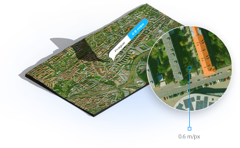
The satellite imagery of the entire world is available in a resolution of min. 10 m/px. Individual countries like e.g. USA, France, Great Britain, Greece, Turkey, Japan, Germany and many more are also available in a higher resolution of up to 0.6 m/px.

